Home » New Zealand Travel Organiser Blog »

Since New Zealand’s trails have gained worldwide fame, we have compiled a list of the best hikes in New Zealand.
New Zealand is one of the world’s best hiking destinations. The scenery is dramatic and ever-changing, the national parks are extensive, and best of all, a network of backcountry huts means you don’t even need to bring a tent while hiking in New Zealand.
In fact, there are so many fantastic New Zealand treks available that your greatest problem will be choosing which ones to sample. From glaciers, fiords, and towering peaks to lush rainforest and golden-sand beaches, New Zealand has a wealth of diverse wilderness just waiting to be explored.
Luckily, this guide has narrowed down thousands of kilometers of trails into the best of the best. From easy day hikes to gruelling week-long wilderness adventures, you are sure to find the perfect track to suit your travel plans on this comprehensive list. Novice hikers will feel comfortable trying popular, well-marked trails, while experienced outdoor adventurers can easily escape the crowds on some of New Zealand’s most remote and inaccessible routes.
The information about each trail includes hiking time, distance, difficulty level, pros and cons of the trail, how to access the trailhead, and other considerations to be aware of when planning your New Zealand trek.
These top New Zealand hikes are spread throughout the North Island and South Island, so if you already have a hiking destination in mind, you can simply choose the trail that best suits your itinerary.
New Zealand’s famous Great Walks are addressed separately, as they are much more expensive than other hikes in New Zealand and must be booked far in advance. However, they showcase some of New Zealand’s most dramatic scenery, so they should not be discounted for these reasons alone.
At the end of this guide, you will find tips specific to hiking in New Zealand, from staying at backcountry huts to crossing flooded rivers.
Table of Contents
South Island | Mt Aspiring National Park
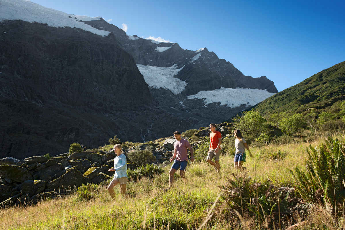
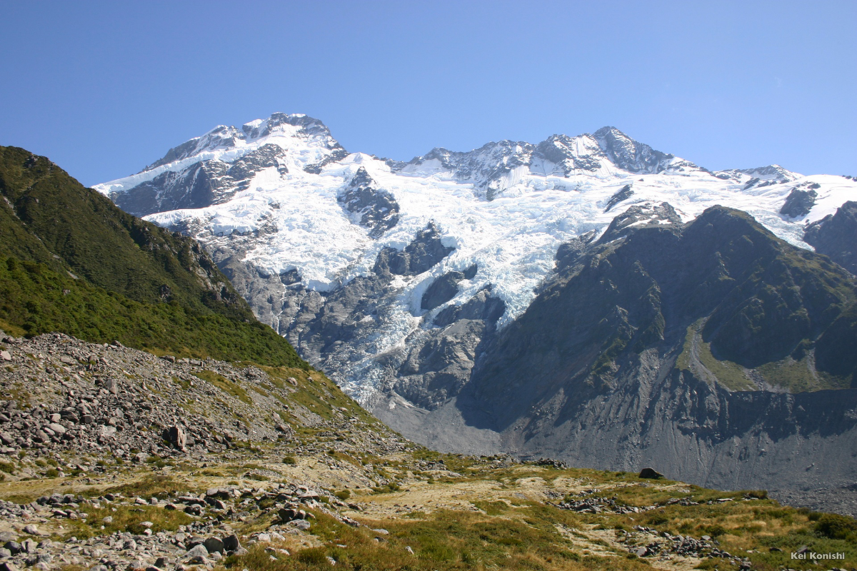
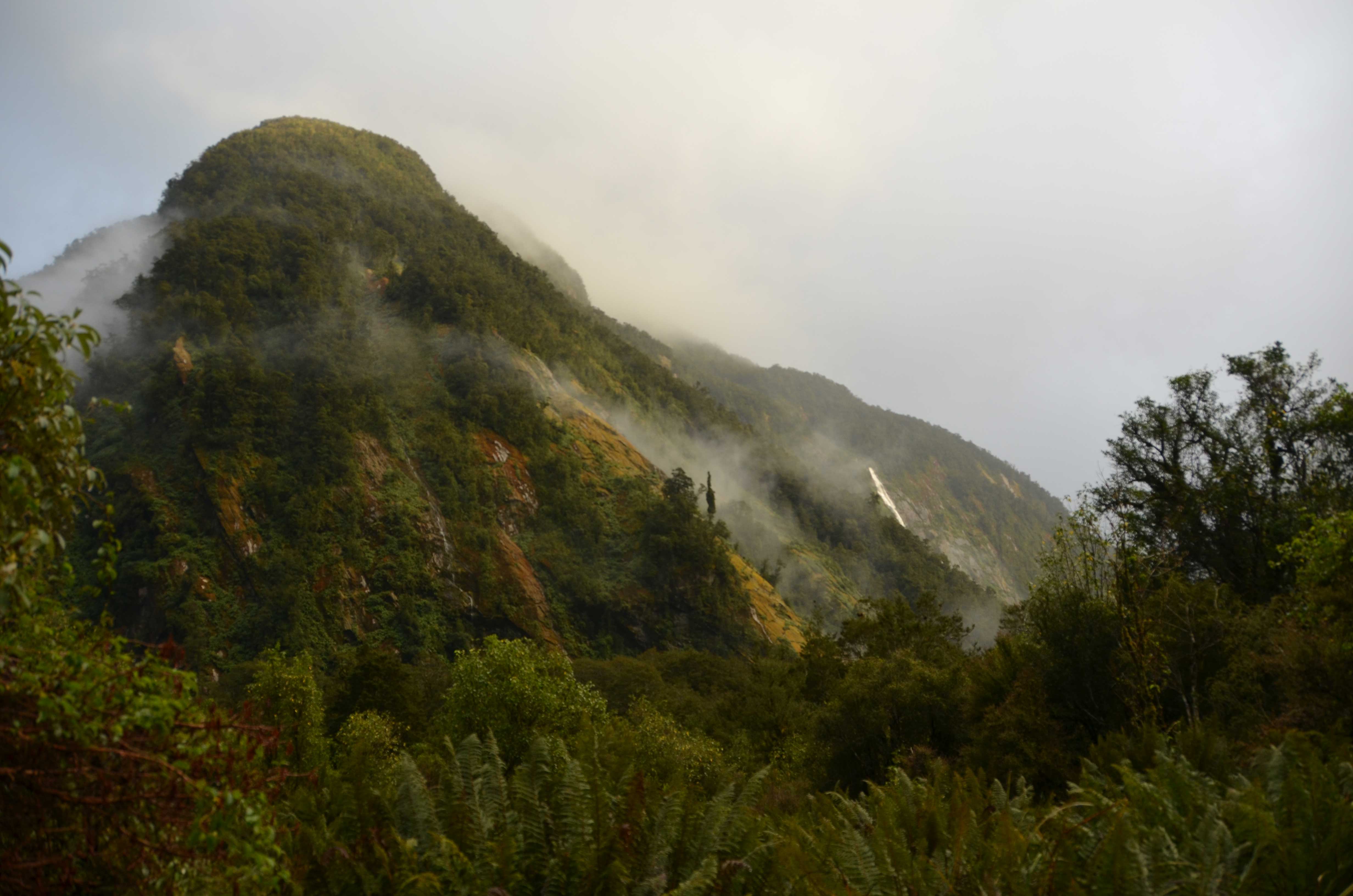
The Rob Roy Glacier Track is probably the most rewarding short day hike in New Zealand. Beginning in the dramatic West Matukituki Valley, where the trail crosses a swing bridge over the turquoise waters of the Matukituki River, the Rob Roy Glacier Track ascends through pristine beech foret before emerging at the foot of the hanging glacier.
Waterfalls cascade from the face of the glacier, which perches high on a rocky mountain face; the breathtaking alpine scene is comparable to Earnslaw Burn, made famous as the destination of an exclusive (and very pricey) helicopter tour. Here you can enjoy your fill of alpine splendor without the hefty price tag.
With gentle grading and a well-maintained trail, the Rob Roy Glacier Track is suitable for almost anyone.
Considerations
Most rental cars are not allowed on the road to Raspberry Flat Car Park, so you will need to arrange a shuttle, hire a car from Adventure Car Rentals Wanaka, or hitchhike to reach the trailhead.
Overview
| Trail Name on DOC Website | Rob Roy Track |
| Distance | 10 kilometers (return) |
| Hiking time | 3-4 hours (return) |
| Nearest town | Wanaka |
| Elevation gain | Moderate, well-graded |
| Pros | • Amazing views for relatively little effort; one of the only easily-reached hanging glaciers in New Zealand • Close to top destinations such as Queenstown and Wanaka; an easy short hike that can fit into most travel schedules • Great-quality trail, usually with no mud |
| Cons | • Popular and can be crowded at times • The road is rough and has fords near the end; most rental car companies do not allow their vehicles to drive to the trailhead. Book a shuttle or rent a car for the day from Adventure Car Rentals Wanaka to get around this. |
| Hiking season | Year-round, dependent on weather |
| Huts and hut fees | None |
| Trailhead | Raspberry Flat Car Park |
South Island | Fiordland National Park
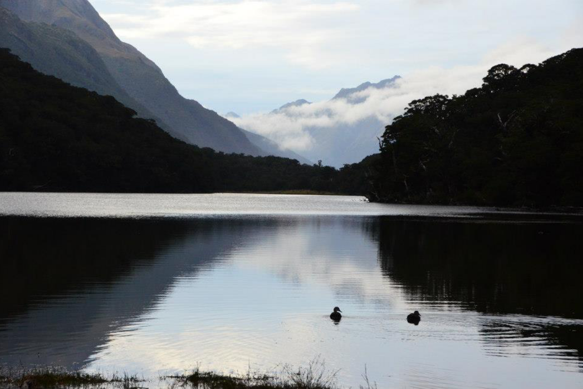
Of the many short walks on offer along the famous Milford Road, the Key Summit Track is the most rewarding. This trail follows the final leg of the Routeburn Track as it climbs to a breathtaking viewpoint over Fiordland National Park, with a mirror-like pool at the top reflecting the surrounding peaks.
Most of the Fiordland terrain is steep and inaccessible, so Key Summit is the only place where you can quickly and easily gain enough elevation to enjoy panoramic views.
The Key Summit Track is well-graded and doable for most hikers.
Considerations
As the Key Summit Track is situated within Fiordland, you can expect rain more often than not. Bring plenty of waterproof layers, and consider postponing or forgoing the hike if visibility is poor, since you won’t be able to see the surrounding mountains from the peak if the cloud cover is low.
Overview
| Trail Name on DOC Website | Routeburn Track: Key Summit Track |
| Distance | 6.8 kilometers (return) |
| Hiking time | 3 hours (return) |
| Nearest town | Te Anau |
| Elevation gain | Moderate, well-graded |
| Pros | • Easily accessed off the Milford Road; a great addition to a day trip from Te Anau to Milford Sound • A rewarding way to sample the highlights of the Routeburn Track even if you aren't hiking the full 3-day Great Walk • Key Summit offers some of the best views of Fiordland National Park without too much time or effort |
| Cons | • Popular and can be crowded at times • Not worth doing if foggy, as there will be no views from the summit |
| Hiking season | Year-round, dependent on weather |
| Huts and hut fees | None |
| Trailhead | The Divide Car Park |
South Island | Mount Aspiring National Park

Of all the Great Walks, the Routeburn Track is best suited for breaking into day-hike sections. Why? Because the scenery is so varied and changes so quickly that even the shortest stroll along the Routeburn Track offers sublime scenery.
Routeburn Falls Hut is an obvious stopping point for a reasonable day hike on the Routeburn Track, but it is equally worthwhile to hike to Routeburn Flats (where the atmospheric beech forest opens up to reveal views of the surrounding mountains) or simply follow the forest trails to enjoy ringing birdsong, peaceful woods, and dramatic views down into the gorge where the Routeburn River cuts through stone.
If you do stop at Routeburn Falls Hut, be sure to visit the balcony of the Great Walks hut, which overlooks the valley below, and continue five minutes farther up the trail to see Routeburn Falls and the alpine valley beyond.
Overview
| Trail Name on DOC Website | Routeburn Track |
| Distance | 7.5 kilometers one way to Routeburn Flats; 9.8 kilometers one way to Routeburn Falls Hut |
| Hiking time | 1.5-2.5 hours one way to Routeburn Flats; 3-4 hours one way to Routeburn Falls Hut |
| Nearest town | Glenorchy (just 45 minutes from Queenstown) |
| Elevation gain | 500 meters to Routeburn Falls Hut, well-graded |
| Pros | • Amazing views, no matter how far you hike • Excellent trail quality, no mud • Take advantage of the shelter offered at Routeburn Falls Hut for a lunch stop if weather is poor • Easy to access from Queenstown |
| Cons | • Popular and can be crowded |
| Hiking season | October through May, depending on weather |
| Huts and hut fees | Routeburn Falls Hut and Routeburn Flats Hut: These are Great Walks Huts, which means if you wish to stay the night to break up your hike or continue farther along the Routeburn Track, you need to book well in advance. Cost is NZD$130 per person per night for non-residents. |
| Trailhead | Routeburn Shelter |
North Island | Tongariro National Park

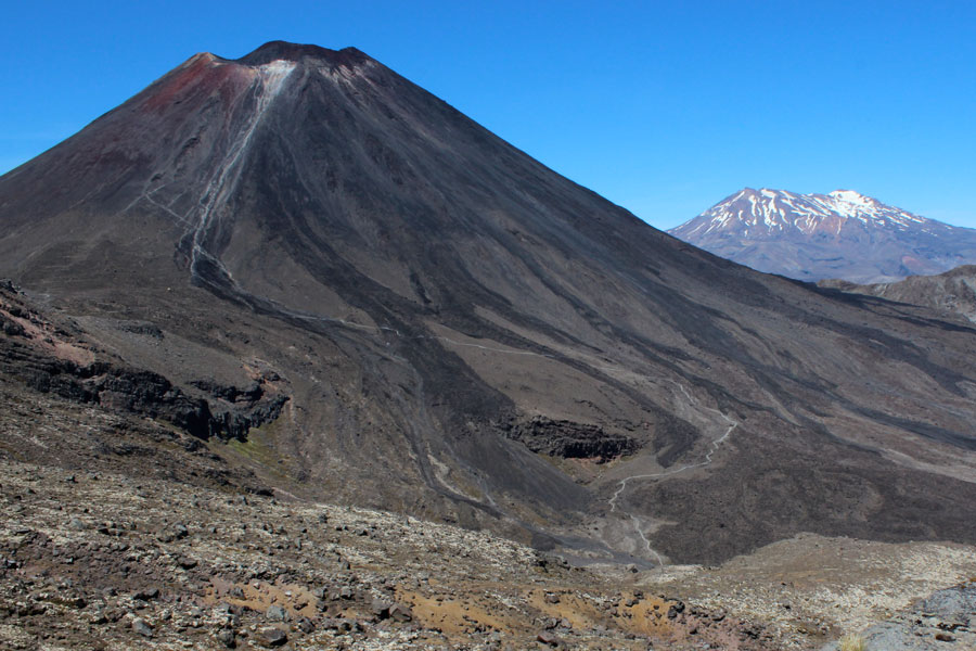
The Tongariro Alpine Crossing is known as one of the top day hikes in the world, which means it attracts all manner of hikers, including those who are not fit enough to complete the 750-meter climb.
But for those willing to brave the crowds and the physical challenge, the Tongariro Crossing is sublime. From twisted lava formations and moonscape-like craters to jewel-bright lakes and towering volcanic cones, the Tongariro Crossing offers some of the world’s most arresting volcanic scenery.
If you can somehow finesse your hiking time to avoid the crowds (if you have two vehicles and can arrange your own transport between trailheads, one option is hiking the trail in reverse and starting in the late morning), the other hikers will clear away and you will have the raw majesty of Tongariro National Park all to yourself.
Considerations
You will need to arrange a shuttle between the trailheads. The car parks at both ends have instated maximum parking time limits during the summer season (October through April), so you will need to either park in one of the private lots provided by a shuttle company or in one of the shuttle office locations or gateway towns (National Park Village, Turangi, Taupo, etc.).
If you hike in winter, you will need to book a guided trip, which will supply you with the necessary crampons, ice axes, and other equipment required.
Overview
| Trail Name on DOC Website | Tongariro Alpine Crossing |
| Distance | 19.4 kilometers |
| Hiking time | 7-8 hours |
| Nearest town | Turangi, National Park Village, and Ohakune |
| Elevation gain | 750 meters, well-graded apart from a steep slope with loose rocks near the top |
| Pros | • Breathtaking views of the volcanic landscapes of Tongariro National Park • Stairs and easy grading mean the hefty elevation gain is doable for most hikers • Convenient, cheap shuttles mean you don’t have to worry about accessing the separate trailheads |
| Cons | • New Zealand’s most popular day hike; can be extremely crowded • Views are frequently restricted by fog |
| Hiking season | Year-round (you need to hike with a guide in winter) |
| Huts and hut fees | Mangatepopo Hut: This is a Great Walks Hut, which means if you wish to stay the night to break up your hike or continue along the Tongariro Northern Circuit, you need to book well in advance. Cost is NZD$36 per adult 18+ per night during the Great Walks season, or NZD$15 per adult per night in winter. |
| Trailhead | Start: Mangatepopo Car Park Finish: Ketetahi Car Park |
South Island

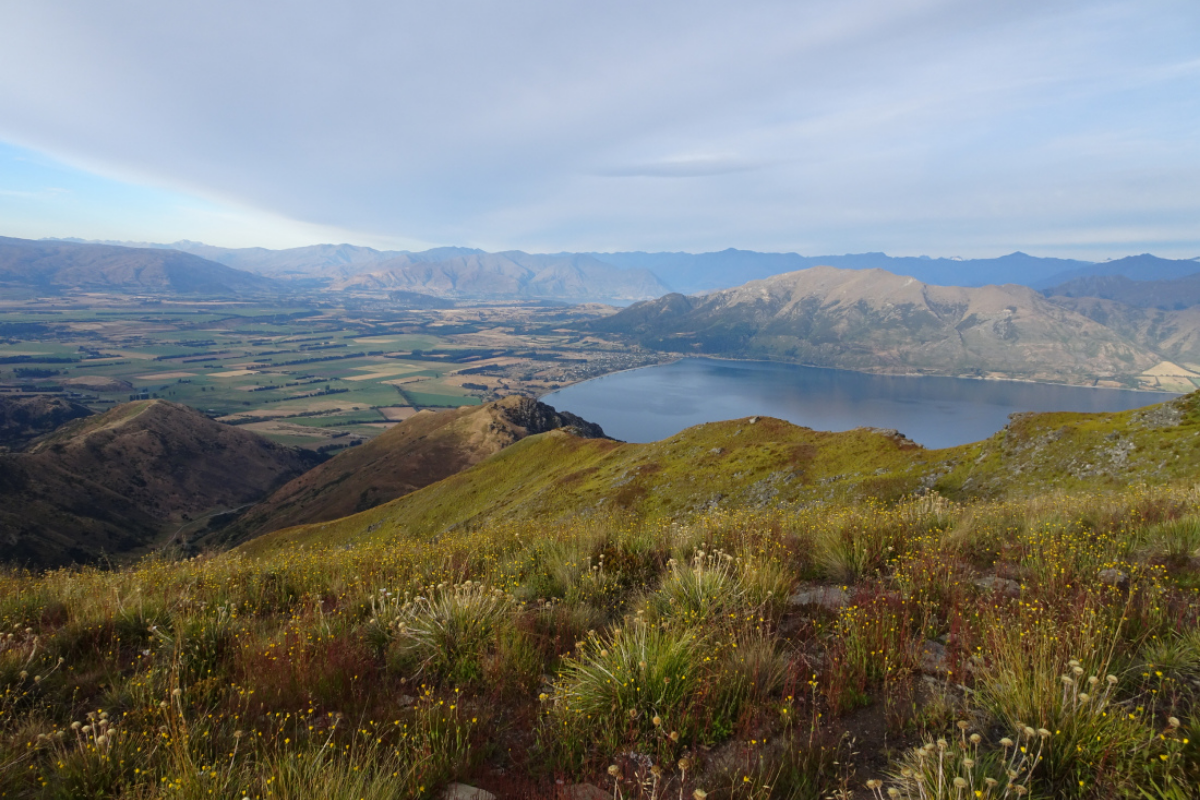
This is a classic track in the Wanaka area. Made famous by Instagram stars posting photos from the top of the peak, with the golden tussock-covered ridge dropping away toward the shores of Lake Wanaka, the Roy’s Peak Track has surged in popularity over the past five years.
The walk itself is a tiring climb that switchbacks through farmland up the side of Roy’s Peak, but the views are worth the effort. The light for photos is best either early in the morning or late in the evening; consider starting at first light to beat the heat, as there is no shade along the way.
Considerations
Roy’s Peak is an extremely popular day hike–at the top, you will often see people queuing for the iconic photo looking out over Lake Wanaka. If you want to avoid the crowds, consider climbing Isthmus Peak or Grandview Peak, both of which are located nearby and offer comparable views with less company.
The Roy’s Peak Track is closed for lambing from October 1st to November 10th each year.
Overview
| Trail Name on DOC Website | Roy's Peak Track |
| Distance | 16 kilometers (return) |
| Hiking time | 5-6 hours (return) |
| Nearest town | Wanaka |
| Elevation gain | 1200 meters, well-graded |
| Pros | • Great views over Lake Wanaka and the surrounding mountains • Easy walking for most of the trail as it follows a farm track |
| Cons | • Popular and can be very crowded at times; limited parking at the trailhead • Views do not change significantly until very close to the summit |
| Hiking season | Year-round (except October lambing closures); you will need ice axe and crampons in winter. The top portion of the track crosses challenging avalanche terrain. |
| Huts and hut fees | None |
| Trailhead | Roy's Peak Car Park |
South Island

Perched just behind Queenstown, Ben Lomond is a convenient and easily-accessible way to escape the chaos of the resort town. Offering more variety on the way up than Roy’s Peak, Ben Lomond also lacks the crowds of its Wanaka counterpart.
If you run out of steam before you reach the peak, the saddle between Ben Lomond and Bowen Peak is a great stopping point, offering equally rewarding views. The final stretch of the trail steepens past this saddle.
Considerations
The track starts from the top of Bob’s Peak, so you can either ride the Skyline Gondola to the start of the trail or follow one of the mountain bike paths as it climbs through pine forest to reach Bob’s Peak.
Overview
| Trail Name on DOC Website | Ben Lomond Track |
| Distance | 14 kilometers (return) from the foot of Bob's Peak |
| Hiking time | 3-4 hours (return) to Ben Lomond Saddle; 6-8 hours (return) to Ben Lomond Summit |
| Nearest town | Queenstown |
| Elevation gain | 1400 meters, steady at first and steep from Ben Lomond Saddle to the summit |
| Pros | • Spectacular panoramic views over Queenstown and the Wakatipu Basin • Can be accessed by walking from downtown Queenstown • Varied scenery with multiple endpoint options |
| Cons | • A very demanding climb |
| Hiking season | Year-round (winter hikers will need alpine equipment including crampons and ice axe) |
| Huts and hut fees | None |
| Trailhead | Skyline Gondola base station (follow the Tiki Trail to the top of Bob's Peak) or the Skyline Complex |
North Island
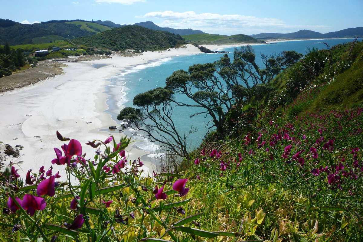
The Bream Head Track is one of the North Island’s premier coastal trails. Climbing from the white sands of Ocean Beach onto a narrow ridge dropping straight to the sea, the trail offers stunning views of the coastline.
Another highlight of the Bream Head Track is the pristine native forest covering the ridge. This coastal broadleaf forest is home to numerous native birds, including kiwis, wood pigeons, and North Island robins.
The climb and descent are both steep, with stairs in places, but the going is relatively easy once you reach the ridge.
Considerations
This is a one-way trail, so you will need to arrange transportation in advance. To create a loop, you can exit down the Peach Cove Track and walk the short distance along the road back to Ocean Beach.
Overview
| Trail Name on DOC Website | Te Whara Track (Bream Head Scenic Reserve) |
| Distance | 7.5 kilometers |
| Hiking time | 5-6 hours |
| Nearest town | Whangarei |
| Elevation gain | 700 meters total, steep climbs include stairs |
| Pros | • Some of the best coastal scenery on the North Island • Not well known among travelers; not crowded • Stairs help make steep climbs easier |
| Cons | • Transport between the trailheads must be arranged |
| Hiking season | Year-round (though keep an eye on the DOC page for occasional track maintenance closures) |
| Huts and hut fees | Peach Cove Hut: This is an optional side trip down off the ridge, and must be booked in advance in order to gain entry. NZD$15 per adult, NZD$7.50 per child. Hut passes and hut tickets are not valid. |
| Trailhead | Start: Ocean Beach Car Park Finish: Urquharts Bay Car Park |
South Island | Mount Aspiring National Park
If you follow the Routeburn Track past Routeburn Falls Hut (see description above) to Harris Saddle, you will hit all the scenic highlights of the Routeburn Track in one long, rewarding day. This Routeburn Track segment easily competes with the Tongariro Crossing for the title of New Zealand’s best day hike.
The ever-changing scenery includes pristine beech forest, a river gorge, towering snow-capped peaks, waterfalls, a sublime alpine valley, and a picturesque lake cradled between mountains. The day hike culminates with breathtaking views over the ridge into Fiordland National Park, where a line of jagged mountains pierces the sky.
Overview
| Trail Name on DOC Website | Routeburn Track |
| Distance | 23 kilometers (return) |
| Hiking time | 7-10 hours (return) |
| Nearest town | Glenorchy (just 45 minutes from Queenstown) |
| Elevation gain | 750 meters, well-graded |
| Pros | • Experience all the highlights of the Routeburn Track in one day • Excellent trail quality, no mud • Take advantage of the shelter offered at Routeburn Falls Hut for a lunch stop if weather is poor • Easy to access from Queenstown |
| Cons | • Popular and can be crowded |
| Hiking season | October through May, depending on weather |
| Huts and hut fees | Routeburn Falls Hut and Routeburn Flats Hut: These are Great Walks Huts, which means if you wish to stay the night to break up your hike or continue farther along the Routeburn Track, you need to book well in advance. Cost is NZD$130 per person per night for non-residents. |
| Trailhead | Routeburn Shelter |
South Island | Arthur’s Pass National Park
Located just outside Arthur’s Pass Village, Avalanche Peak is the best way to see Arthur’s Pass National Park in a day. This challenging hike takes you up the only poled route to a summit in the national park.
The steep, exposed 1,100-meter climb gains elevation quickly, offering breathtaking views of the surrounding peaks. The route can be very dangerous in poor visibility or if snow or ice covers the track, so be prepared to turn around if necessary. Even the short ascent to the bushline offers excellent views over Arthur’s Pass.
Considerations
This is a challenging, exposed route that offers numerous dangerous to unprepared hikers. Check weather conditions carefully, never hike off obvious trails in poor visibility (marker poles can easily vanish in fog), and be prepared to turn around if necessary.
Overview
| Trail Name on DOC Website | Avalanche Peak Route |
| Distance | 5 kilometers (return) |
| Hiking time | 6-8 hours (return) |
| Nearest town | Arthur's Pass Village |
| Elevation gain | 1100 meters, steep |
| Pros | • Some of the best views of Arthur's Pass National Park • The only poled route to a summit in Arthur's Pass |
| Cons | • Very steep and demanding • Can be extremely dangerous in the wrong conditions |
| Hiking season | December through May, dependent on weather |
| Huts and hut fees | None |
| Trailhead | Behind the Arthur's Pass Visitor Centre (Optional: to create a loop, follow Scott's Track on the descent, ending 700 meters from the visitor centre) |
South Island
This stunning day hike takes trampers behind the Remarkables Range. Though very close to downtown Queenstown as the crow flies, the secluded alpine basin feels far removed from civilization.
The trail descends steadily, passing pristine alpine lakes and rivers before dropping into beech forest. Though less dangerous than Avalanche Peak, this route still requires some navigational skills.
Overview
| Trail Name on DOC Website | Lower Wye Creek Track (only describes the second portion of the trail--refer to the Wilderness Magazine entry titled Wye Creek, The Remarkables Conservation Area for full hike description) |
| Distance | 13 kilometers |
| Hiking time | 6-7 hours |
| Nearest town | Queenstown |
| Elevation gain | Very little, track mostly descends |
| Pros | • Close to Queenstown yet feels like pure wilderness • Very little uphill; the trail mostly descends |
| Cons | • A car shuttle needs to be arranged between the trailheads |
| Hiking season | December through May (can be skied by experienced parties in winter) |
| Huts and hut fees | None |
| Trailhead | Start: End of Remarkables Ski Area road Finish: Wye Creek Track trailhead |
South Island | Mount Aspiring National Park

If you have a family member or friend who you are trying to get hooked on backpacking, Aspiring Hut is the hike for you. This is the ideal introduction to multi-day trekking for all ages and experience levels. The mountain and river views are breathtaking from start to finish, the track is more or less flat, and the hike only takes two hours. Oh, and Aspiring Hut is one of the cutest, most comfortable backcountry huts in New Zealand. (It even has flush toilets.)
More experienced hikers can explore further up the valley or tackle the gruelling ascent to Cascade Saddle, Liverpool Hut, or French Ridge Hut.
Considerations
This starts from the same trailhead as the Rob Roy Glacier track, so once again, most rental cars are not allowed on the road to Raspberry Flat Car Park. You will need to arrange a shuttle, hire a car from Adventure Car Rentals Wanaka, or hitchhike to reach the trailhead.
Aspiring Hut is managed by the New Zealand Alpine Club rather than the Department of Conservation, so DOC hut passes and hut tickets are not valid. You can pay the hut ranger in cash when you arrive.
Overview
| Trail Name on DOC Website | West Matukituki Track |
| Distance | 18 kilometers (return) |
| Hiking time | 2 days (2 hours per day) |
| Nearest town | Wanaka |
| Elevation gain | Almost none |
| Pros | • A great first backpacking trip for all ages and abilities • Flat, follows easy farm tracks, and provides great views the whole way |
| Cons | • A few stream crossings mean you may get wet feet • The road is rough and has fords near the end; most rental car companies do not allow their vehicles to drive to the trailhead. Book a shuttle or rent a car for the day from Adventure Car Rentals Wanaka to get around this. |
| Hiking season | Year-round |
| Huts and hut fees | Aspiring Hut: This is a NZAC hut not managed by DOC, which means hut passes and hut tickets are not valid. NZD$30 per adult in summer and NZD$25 per adult in winter; NZD$15 per youth age 11-17 year-round. You can pay the hut ranger on arrival. |
| Trailhead | Raspberry Flat Car Park |
North Island

The popular Pinnacles Hut Track climbs through lush native forest to the unusual Pinnacles rock formation. Stunning views open out over the Coromandel Peninsula, a landscape of lush, rugged hills and undulating coastline.
The popular Pinnacles Hut is New Zealand’s largest, with 80 bunks. The easiest route to the hut follows the Webb Creek Track both ways, or combine this with the Billygoat Track for a longer circuit. Numerous other trails criss-cross this section of the Coromandel Forest Park; more experienced hikers can connect this trail with other Kauaeranga Valley tracks.
Considerations
The Pinnacles Hut must be booked online. DOC hut passes are not valid here.
Overview
| Trail Name on DOC Website | Kauaeranga Kauri Trail (Pinnacles Walk) |
| Distance | 12 kilometers (return) |
| Hiking time | 5-6 hours (return) |
| Nearest town | Thames |
| Elevation gain | Moderate, well-graded, steps in places |
| Pros | • A great family-friendly hike in the Coromandel Peninsula • Great-quality trail and spacious hut |
| Cons | • Popular and can be crowded at times |
| Hiking season | Year-round, dependent on weather |
| Huts and hut fees | Pinnacles Hut: Must be booked online; hut passes and hut tickets are not valid. NZD$15 per adult and NZD$7.50 per child age 5-17. |
| Trailhead | Kauaeranga Road End |
South Island | Aoraki/Mt Cook National Park
In the near-vertical, snow-encrusted majesty of Aoraki/Mt Cook National Park, the Mueller Hut Track is the only place where you can gain elevation without mountaineering equipment. This hut is spectacularly perched on a rocky ridge overlooking Aoraki/Mt Cook, Mueller Glacier, and the surrounding peaks which form the dramatic spine of the Southern Alps.
The trail starts with a gentle stroll along the valley floor, following the Kea Point Track, before zigzagging up to the ridge. The final ascent follows a poled route through loose rocks.
Past the hut, it is possible to scramble to the top of Mt Olliver, an exposed, rocky route. Beyond this, mountaineering equipment is required.
Considerations
Mueller Hut must be booked online. DOC hut passes are not valid.
Overview
| Trail Name on DOC Website | Mueller Hut Route |
| Distance | 10.4 kilometers (return) |
| Hiking time | 2 days (4 hours per day) |
| Nearest town | Mount Cook Village |
| Elevation gain | 1,050 meters, steep |
| Pros | • The best views of Aoraki/Mt Cook National Park • The only way for non-mountaineers to gain elevation in Aoraki/Mt Cook National Park |
| Cons | • Must be booked in advance, and is frequently full. |
| Hiking season | December to March (spring and fall hiking dependent on snow and weather conditions) |
| Huts and hut fees | Mueller Hut: Must be booked in advance; hut passes and hut tickets are not valid. NZD$36 per adult, NZD$15 per child 5-17 years. |
| Trailhead | White Horse Hill Car Park |
South Island | Westland Tai Poutini National Park

Though long, the Copland Track is relatively flat and the trail is well-maintained. What draws hikers to Welcome Flats Hut, though, is not the lush forest, the dramatic mountain views, or the crystal-clear river–it is the natural hot pools just outside the hut. What better way to relax after a long day of hiking than a soak in hot springs, with craggy peaks rising in every direction around?
Most hikes on the West Coast involve dramatic elevation gain or extremely muddy trails or both, so the Copland Track is a great way to explore this beautiful region without dealing with those downsides.
If you want to explore further up the valley, you can enjoy a rewarding morning hike to Douglas Rock Hut before returning to the trailhead, or stay an extra night to make the most of those hot pools.
Considerations
The Copland Track occasionally closes due to flooding, so you will need to bring extra food to the hut in case you need to wait out a rainstorm. The hut ranger will tell you whether or not it is safe to hike.
The hut needs to be booked online–DOC hut passes are not valid here. If you show up without a booking, you will need to pay double the usual price.
Sand flies can be especially brutal here, both at the trailhead and around the hot pools. Bring repellant if you want any hope of enjoying a relaxing soak.
Overview
| Trail Name on DOC Website | Copland Track to Welcome Flat Hut |
| Distance | 18 kilometers (each way) |
| Hiking time | 2 days, 6-8 hours each day |
| Nearest town | Fox Glacier |
| Elevation gain | Moderate, well-graded |
| Pros | • Relatively flat and good-quality track • Hot pools at the end |
| Cons | • The trail closes at times due to heavy rain or slips--bring enough food to wait out a storm if necessary • Sandflies are terrible at the trailhead and the hot pools--bring repellant |
| Hiking season | Year-round, dependent on rain-related closures |
| Huts and hut fees | • Welcome Flats Hut: Must be booked online; hut passes and hut tickets are not valid. NZD$15 per adult, NZD$7.50 per youth 11-17. • Architect Creek Hut: Very basic 2-bunk hut with no heating. Hut passes and hut tickets valid. NZD$5 per adult and NZD$2.50 per child age 11-17. • Douglas Rock Hut: 3 hours past Welcome Flats Hut, on a rougher track. NZD$5 per adult, NZD$2.50 per youth age 11-17. |
| Trailhead | Copland Track Car Park north of Karangarua River bridge |
South Island | Mt Aspiring National Park
This fantastically-situated hut in Haast Pass is a great introduction to just how brutal climbs in New Zealand can get. Rather than switchbacking, this trail cuts a direct path up the ridge, which means elevation gain is swift and tiring.
However, the hiking time is not too long, and the trail is in good condition, so this is a great trail to sample if you want to progress to New Zealand’s more demanding routes.
The deck of Brewster Hut offers breathtaking views over the dramatic mountains of Haast Pass, and a scramble up Mt Armstrong (this portion is rated “challenging,” though no mountaineering equipment is required), just behind Brewster Hut, rewards hikers with an unforgettable alpine panorama.
Considerations
It is worth taking off your shoes to cross the river at the start of the track–you won’t have any danger of getting wet feet past this point.
Overview
| Trail Name on DOC Website | Brewster Track |
| Distance | 5 kilometers (return) |
| Hiking time | 6-8 hours (return) |
| Nearest town | Makarora |
| Elevation gain | 1,000 meters, steep |
| Pros | • Good-quality trail despite the steep climb • Fantastic views over Haast Pass |
| Cons | • Steep and gruelling ascent; those will knee pain will struggle on the descent |
| Hiking season | November through May |
| Huts and hut fees | Brewster Hut: Bookings required; hut passes are valid but NOT hut tickets. NZD$15 per adult, NZD$7.50 per child 11-17 |
| Trailhead | Fantail Falls |
South Island
Unlike the Copland Track, the Mt Brown Hut track perfectly exemplifies West Coast hiking. The climb is gruelling (you will often need to use roots as handholds) and the trail is caked with mud.
But the reward is unbeatable views over the West Coast and a chance to stay in one of New Zealand’s most iconic backcountry huts. And if you are lucky enough to witness a famous West Coast sunset from Mt Brown Hut, you will find the experience hard to top.
Overview
| Trail Name on DOC Website | Mt Brown Hut (For full hike description, refer to Mt Brown Hut listing on remotehuts.co.nz) |
| Distance | 11.5 kilometer loop or 9 kilometer return |
| Hiking time | 2 days, 3-5 hours per day |
| Nearest town | Hokitika |
| Elevation gain | 1,030 meters, steep |
| Pros | • Magnificent views over the West Coast |
| Cons | • Steep, muddy trail eroding in places • Styx River can be challenging to cross. To avoid this, hike both ways on the Geologist Creek route. |
| Hiking season | November through May |
| Huts and hut fees | Mt Brown Hut: Free |
| Trailhead | Styx River Car Park |
South Island
The Breast Hill Track provides views comparable to those enjoyed at the summit of other Wanaka-area peaks such as Roy’s Peak, Isthmus Peak, and Grandview Peak, with the added bonus of a hut at the top to break up the hike.
However, the climb up Breast Hill is much steeper and more precarious than the switchbacking Roy’s Peak Track. Hikers who prefer not to downclimb such a gruelling route can follow the Grandview Track around to Grandview Peak and descend on easy farm tracks. The two trailheads are separated by a few kilometers of road walking.
Overview
| Trail Name on DOC Website | Breast Hill Track (note that this page describes a longer and more difficult loop than the trail outlined above) |
| Distance | 4 kilometers to Pakituhi Hut, 5 kilometers return to Breast Hill summit from there, 22 kilometers from Pakituhi Hut to Grandview Track trailhead |
| Hiking time | 2 days (3-4 hours to Pakituhi Hut, 2 hours return to Breast Hill summit, 6-7 hours to Grandview Track trailhead) |
| Nearest town | Hawea |
| Elevation gain | 950 meters to Pakituhi Hut, 250 additional meters to Breast Hill summit; steep |
| Pros | • Panoramic views over Lake Hawea, Lake Wanaka, and into Mt Aspiring National Park • Many options for hikers; Pakituhi Hut makes a great final destination for a shorter trip |
| Cons | • Very steep and rugged trail |
| Hiking season | December through April |
| Huts and hut fees | Pakituhi Hut: NZD$5 per adult, NZD$2.50 per child age 11-17 |
| Trailhead | Dingle Burn Road Optional Grandview Trac loop finish: car park at end of Nook Road |
South Island | Kahurangi National Park
The little-known Mount Owen Track is one of New Zealand’s most unique backcountry gems. The sides of Mount Owen are covered in dramatic marble formations that resemble glaciers riddled with deep cravasses–the whole scene is otherworldly. This region is also home to New Zealand’s longest cave system, the Bulmer Cave, which starred as the exit to the Mines of Moria in the Lord of the Rings films. (This track takes you to the opposite side of the mountain, so you will not see the cave system.)
The climb to the gorgeous, secluded valley where Granity Pass Hut is situated follows a marked trail, but from here, the route is unmarked. A well-trodden path is easy to follow most of the way up Mt Owen, but once you reach the marble formations, some route-finding skills are required for the final ascent.
Overview
| Trail Name on DOC Website | Mt Owen Tracks and Routes |
| Distance | 8.3 kilometers to Granity Pass Hut |
| Hiking time | 2 days (6 hours each way to Granity Pass Hut, 7 hours return to Mt Owen summit) |
| Nearest town | Nelson |
| Elevation gain | 1,400 meters to Granity Pass Hut, steep |
| Pros | • A very unique, little-visited part of New Zealand • The marble formations on the flanks of Mt Owen are incredible |
| Cons | • Route-finding is required to reach the summit of Mt Owen |
| Hiking season | November through May |
| Huts and hut fees | Granity Pass Hut: NZD$5 per adult, NZD$2.50 per youth 11-17 |
| Trailhead | Courthouse Flat |
South Island | Mount Aspiring National Park

Several hours past Aspiring Hut, Liverpool Hut (and its twin, French Ridge Hut) is perched high on a ridge overlooking the West Matukituki Valley.
The track follows the flat valley floor all the way to the final ascent, at which point it climbs steeply through beech forest before emerging above the bush line. Most of the climb is reasonable, but it steepens at the top, and a few portions feel very exposed. Hikers who suffer from vertigo might struggle with the last thirty minutes to the hut.
From the hut, the views in every direction are staggering.
Considerations
Most rental cars are not allowed on the road to Raspberry Flat Car Park. You will need to arrange a shuttle, hire a car from Adventure Car Rentals Wanaka, or hitchhike to reach the trailhead.
DOC hut passes and hut tickets are not valid at this hut. A bed at Liverpool Hut cannot be reserved in advance, but you must prepay at a DOC visitor center before hiking.
Overview
| Trail Name on DOC Website | Liverpool Track |
| Distance | 15 kilometers each way |
| Hiking time | 2 days (5.5-6.5 hours each way) |
| Nearest town | Wanaka |
| Elevation gain | 1,100 meters, steep |
| Pros | • Great views over the West Matukituki Valley • Easy, relatively flat trail until the final ascent |
| Cons | • The final ascent to the hut is very steep and precarious at times • The road is rough and has fords near the end; most rental car companies do not allow their vehicles to drive to the trailhead. Book a shuttle or rent a car for the day from Adventure Car Rentals Wanaka to get around this. |
| Hiking season | December through April |
| Huts and hut fees | Liverpool Hut: Must be paid for in advance at the Wanaka DOC office; hut tickets are not valid. NZD$15 per adult, NZD$7.50 per youth 11-17 |
| Trailhead | Raspberry Flat Car Park |
South Island

For those wanting to try an easy multi-day hike in the Glenorchy region, the Greenstone-Caples Track is a great alternative to the Routeburn Track. In fact, a link track connects the Greenstone-Caples Track with the Routeburn Track near the Fiordland end, so the two trails can be combined for a longer backcountry experience.
Conveniently, the Greenstone-Caples Track starts and ends in the same place, so no shuttle is required.
Most of the Greenstone-Caples Track follows reasonably flat valleys, with views of mountains, turquoise rivers, and atmospheric beech forest. In the middle, the track climbs over a low saddle, where open meadows offer panoramic views into Fiordland National Park.
The huts are spacious and include flush toilets.
Overview
| Trail Name on DOC Website | Greenstone and Caples Tracks |
| Distance | 61 kilometers |
| Hiking time | 4 days (2-7 hours per day) |
| Nearest town | Glenorchy |
| Elevation gain | Moderate, well-graded |
| Pros | • A great alternative to the Routeburn Track, with an easier climb • Great-quality trail |
| Cons | • Popular and can be crowded at times • The road is rough and has fords near the end; you may need to book transport from Glenorchy or Queenstown depending on your rental car agreement. |
| Hiking season | Year-round, dependent on weather |
| Huts and hut fees | • Mid Caples Hut • McKellar Hut • Greenstone Hut All huts are NZD$15 per adult, NZD$7.50 per youth age 11-17 |
| Trailhead | Car park at end of Greenstone Road |
South Island | Fiordland National Park

Though it does not offer the same high-altitude views as the nearby Milford Track, the Hollyford Track is still a great way to experience the wilderness of Fiordland National Park.
Following the Hollyford River and skirting around the shores of Lake McKerrow, the Hollyford Track is relatively flat and therefore the only multi-day Fiordland hike open year-round.
Parts of the track–especially around Lake McKerrow–can be muddy, but the first portion of the trail is dry and well-maintained.
A combination of planes and jet-boats (and packrafting tours, for even more adventurous hikers) provides many access options to different portions of the trail. Those who prefer not to arrange transport can hike the trail in both directions, or combine it with the Pyke River track to make a circuit (see the section on long hikes below).
Overview
| Trail Name on DOC Website | Hollyford Track |
| Distance | 56 kilometers |
| Hiking time | 4-5 days one way (2-6 hours per day) |
| Nearest town | Te Anau |
| Elevation gain | None |
| Pros | • The only flat multi-day trail through Fiordland National Park • Great-quality trail up to Lake Alabaster (the track is less maintained past there) |
| Cons | • Transport (by jet boat or plane) needs to be arranged from Martins Bay, or else it becomes an 8-day return tramp • The trail is very muddy in places, especially around Lake McKerrow |
| Hiking season | Year-round |
| Huts and hut fees | • Hidden Falls Hut • Lake Alabaster Hut • Demon Trail Hut • Hokuri Hut • Martins Bay Hut The above huts are NZD$15 per adult, NZD$7.50 per youth age 11-17 • McKerrow Island Hut is a standard hut--fees are NZD$5 per adult and NZD$2.50 per youth age 11-17 |
| Trailhead | Start: End of Lower Hollyford Road Finish: Martin's Bay |
South Island

The Queen Charlotte Track passes through the gorgeous Marlborough Sounds, circling around tranquil bays and cresting hills that offer panoramic views as it follows the ridgeline from Ship Cove to Anakiwa.
One of the best parts about the Queen Charlotte Track is the myriad options it offers. Water access between many points along the trail means day hikes and luggage transfers are easily arranged, and accommodation ranges from camping and hostels to luxury lodges.
Most parts of the track are well-maintained, though you may encounter mud.
Considerations
Parts of the Queen Charlotte Track pass through the Queen Charlotte Track Land Cooperative, where a pass is required for access. This can be arranged in Picton.
Boat transport is required to reach the start of the track at Ship Cove. This can also be arranged in Picton.
Overview
| Trail Name on DOC Website | Queen Charlotte Track |
| Distance | 70 kilometers |
| Hiking time | 3-5 days (2-8 hours per day) |
| Nearest town | Picton |
| Elevation gain | Moderate, well-graded; highest continuous climb is 400 meters |
| Pros | • Great views of the Marlborough Sounds • Excellent flexibility in terms of hiking length options, luggage transfers, accommodation options, etc. • Great-quality trail |
| Cons | • Pricier than most hikes--water taxi transport required to the trailhead, plus the QCTLC pass • No huts--accommodation is either camping or hostels/lodges en route |
| Hiking season | Year-round |
| Huts and hut fees | None |
| Trailhead | Start: Ship Cove Finish: Anakiwa |
South Island | Nelson Lakes National Park

The Travers-Sabine Circuit is the best way to experience the alpine beauty of Nelson Lakes National Park. With plenty of easy valley walking, past the shores of deep blue lakes and through peaceful beech forests, the Travers-Sabine Circuit also crosses a high mountain pass surrounded by rugged peaks.
The Upper Travers Hut is situated in one of the loveliest alpine valleys in New Zealand, and Blue Lake (a popular side trip) boasts the world’s clearest water.
Considerations
The pass is not safe to cross in inclement weather–be prepared to wait it out or turn back if necessary.
Overview
| Trail Name on DOC Website | Travers-Sabine Circuit |
| Distance | 80 kilometers |
| Hiking time | 4-7 days (3-9 hours per day) |
| Nearest town | St Arnaud |
| Elevation gain | 1,200 meters total; largest climb between huts is 450 meters from Upper Travers Hut to Travers Saddle |
| Pros | • Takes hikers through the highlights of the stunning Nelson Lakes National Park • A high-quality trail and spacious huts with a steep pass; a great way to progress to harder New Zealand hikes |
| Cons | • Popular and can be crowded at times |
| Hiking season | December through April |
| Huts and hut fees | • Lakehead Hut • John Tait Hut • Upper Travers Hut • West Sabine Hut • Sabine Hut • Speargrass Hut All of the above are NZD$15 per adult, NZD$7.50 per youth age 11-17 |
| Trailhead | St Arnaud |
South Island | Mount Aspiring National Park

The Rees-Dart Track is another popular Glenorchy-area circuit. Hiking times are longer than on the nearby Greenstone-Caples Track, but the huts are equally spacious and the trail is generally of a high standard.
The track leads through beech forest, over a low saddle, and past dramatic mountains as it links the Rees and Dart Valleys. After a slip in the Dart Valley created a new lake that forced the circuit to remain closed for several years, a new route was cut high into the hillside above the lake–this portion is more challenging than other parts of the track.
A popular side trip leads to Cascade Saddle–this is a much less dangerous way to access the saddle than the route leading up from Mt Aspiring Hut (see below).
Considerations
Transport between the trailheads can be hard to arrange. Hikers may need to walk to the end of the access roads to hitchhike, or pre-arrange a shuttle or car swap.
Overview
| Trail Name on DOC Website | Rob Roy Track |
| Distance | 63 kilometers |
| Hiking time | 4-5 days (4-8 hours per day) |
| Nearest town | Glenorchy |
| Elevation gain | 1,050 meters total, only steep around new Dart Valley lake and close to Rees Saddle |
| Pros | • Great views of Mt Aspiring National Park, with several rewarding side hike options • Generally high-quality trail |
| Cons | • Transport may be hard to arrange to the trailheads, which could mean long road-walks at the beginning and end of the trail. |
| Hiking season | November through may, depending on weather |
| Huts and hut fees | • Shelter Rock Hut • Dart Hut • Daleys Flat Hut All of the above are NZD$15 per adult, NZD$7.50 per youth age 11-17 |
| Trailhead | Start: Muddy Creek Car Park Finish: Chinamans Car Park |
South Island
This little-known track is mostly hiked by those tackling the Te Araroa Trail, a thru-hike running the length of New Zealand. But it deserves more attention–with its historic huts, varied landscapes, and breathtaking views over Lake Tekapo and Aoraki/Mt Cook, the Two Thumb Track is one of the highlights of the central South Island.
Starting in the Rangitata River valley, the track climbs into golden tussock-country. Nights are spent at historic musterers’ huts, which are a classic sight in the central South Island.
After three days of crossing tussock-covered ridges and following streams, the track reaches its highest point at Stag Saddle. If the weather is good, don’t miss the unmarked (but easy to follow in good conditions) route descending the ridge to the right of the saddle. From here, a sudden vista of sheer, white-capped peaks and the turquoise waters of Lake Tekapo confronts you.
Considerations
The trailheads are far apart, but transportation between the two is easy to pre-arrange through Alps2Ocean.
At times, the marker poles are widely spaced and difficult to locate, especially in river valleys. A GPS would be very helpful to bring.
Overview
| Trail Name on DOC Website | None (refer to the Te Araroa trail notes titled Two Thumb Track for full trail description) |
| Distance | 72 kilometers |
| Hiking time | 4 days (4-7 hours per day) |
| Nearest town | Geraldine, Lake Tekapo |
| Elevation gain | Several steep climbs |
| Pros | • A little-known highlight of the central South Island, with breathtaking views over Lake Tekapo and the mountains surrounding Aoraki/Mt Cook • Stay in historic musterers' huts |
| Cons | • The marker poles can be hard to locate at times; often times travel around riverbeds is not on a track • Though picturesque and full of history, the musterers' huts are a bit shabby • The first day requires numerous river crossings that can be challenging--especially the final crossing. Practice river safety and link up with another hiker; don't attempt to cross if levels are elevated. |
| Hiking season | December through April |
| Huts and hut fees | • Crooked Spur Hut • Stone Hut • Royal Hut The above are NZD$5 per adult, NZD$2.50 per youth • Camp Stream Hut is owned by the Mackenzie Alpine Trust, who ask for a NZD$10 cash donation per person to stay. Hut passes and hut tickets are not valid. |
| Trailhead | Start: Bush Stream Car Park Finish: Boundary Stream Car Park |
This challenging hike offers some of the most dramatic views anywhere in New Zealand. From the steep-walled West Matukituki Valley to the glistening Dart Glacier and sheer rock cliffs lining the upper Dart Valley, the Cascade Saddle Route offers great variety and a sense of discovering untouched wilderness.
However, this route should not be attempted by inexperienced hikers or those unable to cope with heights. Multiple fatalities have occurred on the climb between Aspiring Hut and Cascade Saddle, so only tackle this section in perfect weather.
The hike begins with an easy walk in to Aspiring Hut. Don’t be tempted to combine this with the next day–the climb over Cascade Saddle to Dart Hut takes a gruelling 10 hours.
From Aspiring Hut, the track begins a near-vertical ascent to Cascade Saddle. Once the trail leaves the trees, the climb grows even steeper; at times you will need to scramble up steep rock bluffs. A heavy backpack can throw you off-balance here, so pack smart.
From the top of the ridge, the track is much gentler, and the descent into the upper Dart Valley is not too steep. For this reason, it is much safer to hike the Cascade Saddle Route from the West Matukituki Valley to the Rees Valley, rather than the reverse direction.
From the Dart Hut, the route joins up with the Rees-Valley Track for the final stretch to the Rees Valley Road.
Considerations
The Cascade Saddle Route is very dangerous in the wrong conditions. Listen to the recommendations of the hut ranger at Aspiring Hut, and be prepared to change your plans if necessary.
The two trailheads are far apart. A shuttle can be arranged to Raspberry Flat Car Park, but you will need to either hitchhike or arrange a friend to collect you from the end of Rees Valley Road. If you plan to hitchhike, you may need to walk an additional 3-4 hours to the end of Rees Valley Road, where it joins up with the main road leading past Glenorchy, as there is very little traffic on Rees Valley Road.
Overview
| Trail Name on DOC Website | Cascade Saddle Route |
| Distance | 54 kilometers |
| Hiking time | 4-5 days (2-10 hours per day) |
| Nearest town | Wanaka, Glenorchy |
| Elevation gain | 1,300 meters on the highest climb, very steep |
| Pros | • Incredible backcountry, with glacier, river, mountain, and valley views |
| Cons | • The climb to Cascade Saddle is on very exposed, steep bluffs that require hikers to use their hands. Good balance is required. • The climb to Cascade Saddle can be fatal in anything other than perfect weather. Check the forecasts carefully, be willing to turn back, and listen to the recommendations of the hut ranger at Aspiring Hut. • The road is rough and has fords near the end; most rental car companies do not allow their vehicles to drive to the trailhead. Book a shuttle or rent a car for the day from Adventure Car Rentals Wanaka to get around this. |
| Hiking season | December through March, depending on weather |
| Huts and hut fees | • Aspiring Hut: This is a NZAC hut not managed by DOC, which means hut passes and hut tickets are not valid. NZD$30 per adult; NZD$15 per youth age 11-17. You can pay the hut ranger on arrival. • Dart Hut • Shelter Rock Hut The above are NZD$15 per adult, NZD$7.50 per youth age 11-17 |
| Trailhead | Start: Raspberry Flat Car Park Finish: Muddy Creek Car Park |
The Gillespie Pass Circuit rewards experienced hikers with superb alpine scenery, dramatic peaks, and an optional side trip to the magnificent Crucible Lake, where icebergs are often found floating on the surface until late summer.
Though it includes a dizzying ascent, rough trails, and a significant river crossing, the Gillespie Pass Circuit is much less dangerous than the Cascade Saddle Route, so it makes a good first challenge for those ready to tackle some of New Zealand’s more remote and difficult backcountry.
The track begins with a river-crossing over the Makarora River, though this can be avoided when river levels are high by walking the Blue-Young Link Track, which begins at the Blue Pools.
After gradually ascending the Young Valley, the track climbs straight up Gillespie Pass. At the top, Mt Awful dominates the breathtaking panorama.
A gruelling descent leads to Siberia Valley, where you may spot day-trippers landing in a bright orange plane for the “Siberia Experience” (which ends in the aforementioned jet-boat ride). The day trip to Crucible Lake departs from near Siberia Hut.
If you choose to stay in Kerin Forks Hut, the final hut along this circuit, keep in mind that you must cross the Wilkin River to reach the hut, and then cross back to hike out the following day.
Considerations
Many hikers who wish to avoid the river crossing(s) book a jet-boat trip down Wilkin Valley. If you are on a tight schedule or inexperienced with river crossings, this is highly recommended.
The two trailheads are not that far apart, but hitchhiking between the two can be tricky. If you book the jet-boat ride out, you may have an easier time arranging transportation.
Overview
| Trail Name on DOC Website | Gillaspie Pass Circuit |
| Distance | 58 kilometers |
| Hiking time | 3-4 days (4-8 hours per day) |
| Nearest town | Makarora |
| Elevation gain | 1,300 meters total, steep |
| Pros | • Remote backcountry with amazing views • Option to shorten the hike with a jet-boat ride down the Wilkin Valley |
| Cons | • Very long, steep descent to Siberia Hut on unformed trails • If you don't opt for the jet-boat trip, the Makarora River crossing can be impassable if levels are high • Can be crowded at Siberia Hut due to the Siberia Experience day tour • Transport must be arranged between trailheads, or it is a long road-walk to connect the circuit |
| Hiking season | December through April |
| Huts and hut fees | • Young Hut • Siberia Hut • Kerin Fork Hut All the above are NZD$15 per adult and NZD$7.50 per youth age 11-17 |
| Trailhead | Start: Blue Pools Car Park (or opposite the Young Valley, if the Makarora River is safe to cross) Finish: opposite the Wilkin Valley |
North Island

The Tararua Range boasts the most dramatic (non-volcanic) mountains on the North Island. Relatively unknown to hikers from overseas, the Tararuas are very popular with trampers from Wellington.
There are countless 3- to 4-day routes through the Tararua Ranges; one classic trip is the Southern Crossing. Another is the portion of the Te Araroa Trail running from Poads Road to Otaki Forks.
The Tararuas are notorious for heavy fog and cold Southerlies, making them far more dangerous than most mountains in New Zealand. No matter which route you choose, you are likely to hike at least one day in fog; navigation equipment is essential. The ridges are exposed and steep-sided, so take extreme care when choosing your route if the next marker pole is not visible.
Considerations
Most multi-day hikes through the Tararua Range require transport between the trailheads, which may not be easy to arrange. Consider tagging along with the Wellington Tramping and Mountaineering Club if one of their Tararua Range hikes coincides with your travel dates.
Overview
| Trail Name on DOC Website | Tararua Southern Crossing (New Zealand Tramper has a more thorough route description titled Southern Crossing of the Tararuas) |
| Distance | 32 kilometers |
| Hiking time | 3 days (2-8 hours per day) |
| Nearest town | Otaki |
| Elevation gain | Multiple steep ascents |
| Pros | • One of the classic routes through the Tararuas, with amazing views of the range as well as the nearby coastline |
| Cons | • The Tararuas suffer from frequent fog, Southerlies, and other dangerous weather conditions. Plan your trip carefully. • Tranport must be arranged between the trailheads • Trails in the Tararua Range are frequently muddy |
| Hiking season | Can be hiked year-round by trampers experienced with snow hiking, using proper equipment |
| Huts and hut fees | • Field Hut • Kime Hut • Alpha Hut The above huts are each NZD$5 per adult, NZD$2.50 per youth age 11-17 |
| Trailhead | Start: Otaki Forks Finish: Kaitoke |
There are no truly easy hikes longer than 4 days in New Zealand. This is partly because many longer hikes eventually cross a high mountain pass, and partly because the effort of carrying more than 4 days’ worth of food adds to the challenge of any backcountry undertaking.
North Island | Tongariro National Park
If you are looking for backcountry solitude, the Round the Mountain Track circling Mt Ruapehu is the perfect way to experience the volcanic landscapes of Tongariro National Park while avoiding the crowds on the Tongariro Crossing.
This track passes through mountain beech forest, crosses the windswept sands and volcanic rock of the Rangipo Desert, climbs to alpine herb fields and tussock country, and offers views of pounding waterfalls.
The Round the Mountain Circuit is one of New Zealand’s only longer hikes that forms a perfect circuit, beginning and ending in the same place.
Considerations
There are unbridged river crossings on this track, so be prepared to wait out heavy rain.
Overview
| Trail Name on DOC Website | Round the Mountain Track |
| Distance | 66 kilometers |
| Hiking time | 4-6 days (5-8 hours per day) |
| Nearest town | Whakapapa Village |
| Elevation gain | Moderate, well-graded |
| Pros | • A much less crowded way to experience the volcanic landscapes of Tongariro National Park |
| Cons | • Footing can be difficult in places. |
| Hiking season | Year-round, dependent on weather (winter tramping requires suitable equipment and should only be attempted by experienced parties) |
| Huts and hut fees | • Rangipo Hut • Mangaehuehu Hut • Blyth Hut • Mangaturuturu Hut • Whakapapaiti Hut The above are NZD$15 per adult, NZD$7.50 per youth age 11-17 Waihohonu Hut is a Great Walks Hut and requires advance booking in the Great Walks season. NZD$36 per adult, hut passes and tickets not valid. |
| Trailhead | Whakapapa Village |
South Island | Fiordland National Park

The Hollyford-Pyke Circuit is a great way to turn the Hollyford Track into a loop. The Pyke Valley is just as beautiful as the Hollyford Valley, with two pristine lakes and mountains framing the river.
After leaving the Hollyford Track, hikers face either a densely overgrown section of trail or a beach walk that involves dodging potentially aggressive seals. (Most people opt for the beach route.) From there, the track follows the beach to the first hut of the Pyke Track. The trail crosses a very low saddle before entering the Pyke Valley, where it follows the Pyke River through muddy marshes before linking back up with the Hollyford Track.
The Hollyford-Pyke Circuit is popular with packrafters, whom you might see along the way–those traveling by water get to avoid the mud and see more mountain scenery than hikers. (Packrafting New Zealand, based in Te Anau, offers a beginner course that includes a trip on the Hollyford-Pyke Circuit, if you are interested in trying the multi-sport adventure.)
Considerations
The Pyke Valley is impassable when rivers rise, so be prepared to wait or return via the Hollyford Track if necessary.
Overview
| Trail Name on DOC Website | Pyke-Big Bay Route (refer to the Hollyford Track DOC page for the first stretch of the loop) |
| Distance | 144 kilometers |
| Hiking time | 10 days (2-10 hours per day) |
| Nearest town | Te Anau |
| Elevation gain | Very little |
| Pros | • A great way to turn the Hollyford Track into a loop • The Pyke Track is remote and uncrowded |
| Cons | • Extremely muddy and overgrown in places • Several unbridged river crossings; hikers need to bring two extra days' worth of food in case they need to wait out a flooded river |
| Hiking season | Year-round, dependent on weather |
| Huts and hut fees | • Huts on the Hollyford Track are mainly serviced huts, NZD$15 adult and NZD$7.50 per youth age 11-17. • Huts on the Pyke-Big Bay Route are NZD$5 per adult and NZD$2.50 per youth age 11-17. |
| Trailhead | Hollyford Road End |
South Island | Fiordland National Park

Widely regarded as New Zealand’s hardest hike, the Dusky Track is a formidable challenge.
Though the trail is easy to follow, hikers should expect to be stuck at huts for at least 2-3 nights due to rivers rising. Rain in Fiordland is inevitable, and Loch Maree Hut gets cut off in all directions once the valley floods (which happens frequently). Add to this the knee-deep mud and waist-deep water crossings, two steep passes, and countless dizzying three-wire bridges, and you can see why the Dusky Track is only suitable for the hardiest hikers.
For those who brave its legendary challenges, the Dusky Track gives hikers a taste of true wilderness as it cuts deep into a remote, untouched corner of Fiordland National Park. The trail links Lake Hauroko with Lake Manapouri, which means water transport is needed to access both trailheads, and as you climb past the bushline and take in endless views of the towering Fiordland peaks, you begin to sense the scale of this vast backcountry paradise.
Considerations
Most hikers start from the Lake Hauroko end of the Dusky Track, as transport to the trailhead is only offered twice a week and you never know what day you will finish hiking. At the Lake Manapouri end, hikers can jump onto the next Real Journeys boat ferrying tour groups across en route from Doubtful Sound. These travel several times per day.
The two-day side hike to Dusky Sound leaves from Loch Maree Hut. If you end up stuck at Loch Maree Hut due to flooding, you can skip this to make up for lost time. However, it is a rewarding excursion for those who do manage to fit it in.
Overview
| Trail Name on DOC Website | Dusk Track |
| Distance | 84 kilometers |
| Hiking time | 8-10 days (4-8 hours per day) |
| Nearest town | Te Anau, Manapouri |
| Elevation gain | Two steep climbs |
| Pros | • Takes hikers through the most dramatic, remote Fiordland scenery • Very few hikers attempt this track, so you can be sure to enjoy solitude |
| Cons | • Very deep mud in places • Hikers need to plan to get stuck at least 2-3 extra nights due to rivers rising. The trails around Loch Maree Hut are impassable if the dead stumps in Loch Maree are not visible. • Expensive due to boat transport required to both trailheads. |
| Hiking season | December through April |
| Huts and hut fees | All 8 huts are NZD$5 per adult per night, NZD$2.50 per youth per night |
| Trailhead | Start: Hauroko Burn Hut Finish: Wilmot Pass Road |
South Island | Nelson Lakes National Park
For those looking for a challenging long hike through sublime mountain scenery, the Waiau Pass Route is among New Zealand’s very best hikes. Starting along the Travers-Sabine Circuit, this route climbs past Lake Constance and over Waiau Pass before eventually linking up with the popular St James Walkway near Lewis Pass.
To enjoy the best possible views, start from St Arnaud, as this will take you across the stunning Travers Saddle. Or, to shorten the hike, begin from the Sabine Valley and cut out a major climb.
Waiau Pass is a dangerous alpine route that should not be attempted in poor visibility or inclement weather. However, the most dangerous portion of the trail is the sidle around Lake Constance, which crosses above steep bluffs where footing can be tricky. A fall here could prove fatal.
Past Waiau Hut, on the southern side of the pass, the track is much easier–the final stretch is well-maintained and well-graded.
Considerations
The track begins and ends in completely different places. Transport can be arranged from Nelson to St Arnaud, and from the end of the St James Walkway to either Hanmer Springs or Christchurch.
This pass is dangerous, especially in poor conditions. Be prepared to wait for good weather, and try to team up with other hikers for the ascent over Waiau Pass if you are traveling solo. One hut book entry from summer 2018/2019 described the experience of a solo tramper who slipped and fell off a bluff over Lake Constance; she barely managed to summon up the strength to rescue herself. If her injuries had prevented her from hiking further, she might not have been found.
Overview
| Trail Name on DOC Website | Lewis Pass - Waiau Pass - Blue Lake Route (this DOC page assumes the opposite direction as the description above. Hiking north to south, as per the above description, is the easier direction to tackle Waiau Pass.) |
| Distance | 115 kilometers |
| Hiking time | 8-10 days (3-12 hours per day) |
| Nearest town | St Arnaud, Hanmer Springs |
| Elevation gain | Two steep passes |
| Pros | • Some of New Zealand's best alpine scenery |
| Cons | • The climb past Lake Constance and over Waiau Pass is very dangerous in inclement conditions. Footing is tricky and can be slippery. Don't hike alone, and be prepared to wait for clear weather. • The two trailheads are far apart. Transport needs to be arranged to each. |
| Hiking season | December through April |
| Huts and hut fees | • Most huts en route are serviced; NZD$15 per adult, NZD$7.50 per youth age 11-17. • Waiau Hut is NZD$5 per adult, NZD$2.50 per youth. |
| Trailhead | Start: St Arnaud Finish: Boyle Village |
South Island

The little-visited Richmond Range has only regained popularity in recent years after it was designated a section of the Te Araroa Trail. While the traverse over Little Rintoul and Mt Rintoul is even more harrowing than the Waiau Pass Route, the views are more than worth the effort.
After ascending to Starveall Hut, the main Richmond Range route follows the ridgeline for several days, with sweeping panoramic views in every direction. The Marlborough Sounds and the Nelson coastline are visible in the distance, while Little Rintoul and Mt Rintoul loom ahead.
The final 50 meters to the top of Little Rintoul hugs a precarious cliff face, and the descent to the saddle between the two peaks is equally harrowing. Thankfully Mt Rintoul is easier.
Hikers who want a shorter traverse can exit the range when the track descends to the Wairoa River. Continuing on, the route follows the river for a day before crossing a geologically unique mountain landscape of red rocks and little vegetation.
Considerations
Private transport will likely need to be arranged to the Hackett Picnic Area. On the southern end, the trail ends close to St Arnaud. You can either hitchhike to St Arnaud or road-walk the final distance; onward transportation can be arranged from there.
Hikers need a good head for a heights and sense of balance. There are several river crossings that can become impassable after rain–be prepared to wait for levels to recede or turn back if necessary.
Overview
| Trail Name on DOC Website | Alpine Route (for the first portion of the route through to the Wairoa River road end. For the complete route description, refer to the Te Araroa trail notes titled Richmond Alpine Track.) |
| Distance | 94 kilometers |
| Hiking time | 7-10 days (5-10 hours per day) |
| Nearest town | Nelson, St Arnaud |
| Elevation gain | The largest single climb is 900 meters; many steep climbs throughout the route |
| Pros | • Rugged, remote mountains with epic views |
| Cons | • The ascent up Little Rintoul and down the saddle between Little Rintoul and Mt Rintoul is exposed and nerve-wracking at times. The Wairoa River track also has sheer dropoffs. • The Motueka River crossing can be very dangerous after rain. • There are few water supplies on the ridge-tops, and the hut water tanks occasionally run dry. Bring extra water just in case. |
| Hiking season | December through April |
| Huts and hut fees | All huts are NZD$5 per adult per night and NZD$2.50 per child per night |
| Trailhead | Start: Hacket Picnic Area Finish: SH63 8 kilometers from St Arnaud |
Both islands
This 4- to 5-month thru-hike running the length of New Zealand has the somewhat misleading tagline, “A Walking Trail from Cape Reinga to Bluff.” The Te Araroa is at times a tramping track, a backcountry route, a beach walk, a paddle, a bushwhacking adventure, and a road walk–but very rarely something as simple as a “walking trail.”
If you are a seasoned hiker looking for the adventure of a lifetime, New Zealand’s Te Araroa Trail is an incredible way to see New Zealand.
And if you want to cherry-pick the highlights, the Te Araroa often takes you deep into rarely-visited backcountry as it follows the spine of the Southern Alps and the remote forests and coasts of Northland.
The South Island is almost exclusively comprised of hiking trails, with a few short road or farmland sections linking these, whereas the North Island has a much heavier concentration of road walking. If you choose just one island, the South Island is the obvious choice.
Several portions of the Te Araroa Trail overlap with the hikes described above. These include the Bream Head Track, the Tongariro Crossing, the Tararua Range, the Queen Charlotte Track, the Richmond Range, the Travers-Sabine Circuit, the Waiau Pass Route, the Two Thumb Track, the Breast Hill Track, and the Greenstone-Caples Track.
Overview
| Trail Name on DOC Website | None (refer to the Te Araroa website for up-to-date trail information and maps) |
| Distance | 3,000 kilometers |
| Hiking time | 4-6 months |
| Nearest town | The Te Araroa Trail passes through numerous towns, especially on the North Island. In some places, hitchhiking or prearranged transport is required for resupply stops. |
| Elevation gain | Many steep climbs |
| Pros | • A great way to see New Zealand; the experience of a lifetime • Many huts along the trail on the South Island mean you will rarely need to camp south of Wellington |
| Cons | • Several long sections of road walking, especially on the North Island • The trail includes hazards and annoyances such as dangerous river crossings, exposed alpine passes, routefinding sections, overgrown tracks, copious mud, and tedious beach-walking. |
| Hiking season | Depends on the section of the trail. Most hikers begin in mid-October from Cape Reinga. |
| Huts and hut fees | Various (the trail never requires hikers to stay at Great Walks huts) |
| Trailhead | Start: Cape Reinga Finish: Bluff |
New Zealand’s nine (soon to be ten) Great Walks are internationally renowned—and heavily advertised overseas. For first-time or solo backpackers, these are a great option because they offer well-maintained trails, great hut facilities (often including stoves), easy-to-coordinate transportation from nearby towns, gear rentals if you don’t have your own, and guided and gear-transfer options for those wanting a more personalized or simplified experience.
Plus, the Great Walks pass through some of New Zealand’s most stunning backcountry.
However, there are drawbacks to these hikes as well.
First, for visitors from overseas, the hut tickets are much more expensive than any other huts in New Zealand (often over NZD$100 per night, compared to NZD$15 per night at most other backcountry huts).
Second, the most popular Great Walks—especially the Milford Track and Routeburn Track—book out months in advance. The Milford Track commonly fills up within weeks of its booking system opening for the season.
There is a wealth of information available about these hikes online, as well as in the convenient free brochures available at most i-Sites and Department of Conservation visitor centers, so the below is just a brief overview. The Great Walks are listed in order of our personal preference, starting with our favorite.
South Island | Mount Aspiring National Park and Fiordland National Park

As you can see from the day hikes above, the Routeburn Track is easy to experience in parts for those who do not wish to hike the full Great Walk. However, if you are able to secure bookings at the huts, the full 3-day walk is well worth doing. In addition to the highlights found on the Harris Saddle day hike, those who tackle the full Routeburn Track will enjoy views of the glistening Lake Mackenzie crowned by towering peaks, as well as numerous waterfalls cascading beside the track.
South Island | Fiordland National Park
The Kepler Track is a great way to see deep into Fiordland National Park. Because a large portion of this Great Walk follows an undulating, tussock-covered ridge, hikers can enjoy panoramic views over lake and mountain scenery for hours on end. This is a rare New Zealand trekking experience. After descending from the ridge, the Kepler Track follows a lovely open valley ringed by high peaks before skirting the shores of Lake Manapouri. As the Kepler Track is less popular than the nearby Routeburn Track and Milford Track, you are more likely to secure spaces in the huts.
South Island | Fiordland National Park
Often touted as the “Finest Walk in the World,” the Milford Track tends to fill up within weeks of its booking system opening for the year. If you don’t plan well in advance, you are unlikely to find space on this famous Great Walk–unless you book a guided hike, which uses different lodges. For the lucky few who manage to book a spot on the Milford Track, the trail follows a sheer-sided valley, climbs a breathtaking pass, and passes through lush rainforest. If you happen to encounter rain (which is more than likely), thousands of waterfalls begin cascading from the towering rock faces lining the Milford Track, an enchanting sight.
North Island | Tongariro National Park
Since most visitors in Tongariro National Park are drawn to the Tongariro Crossing, this Great Walk is relatively uncrowded. The Tongariro Northern Circuit circles the flanks of Mt Tongariro, crossing barren volcanic plains and weaving through twisted lava formations, before it links up with the most scenic portion of the Tongariro Alpine Crossing. For hikers who enjoy volcanic landscapes, the Tongariro Northern Circuit is well worth the extra effort.
South Island | Kahurangi National Park
This diverse Great Walk crosses through the tussock highlands and beech forest of Kahurangi National Park before dropping to the West Coast, where it follows a rugged beach past rainforest studded with Nikau palms.
South Island | Abel Tasman National Park

Most commonly experienced on day trips that combine water taxis with walking and/or kayaking, the Abel Tasman Coast Track follows the stunning golden-sand beaches of Abel Tasman National Park.
North Island |Whanganui National Park
Not a hike at all, the Whanganui River Journey is a multi-day paddle down the Whanganui River that has somehow been classified among the Great Walks. With many operators providing canoes, kayaks, and transfers along different sections of the Whanganui River, this trip can be customised as much as you wish. The upper stretches lead through steep-walled canyons dripping with ferns and moss, while lower down the Whanganui River widens and the canyon walls flatten out.
North Island
The Lake Waikaremoana Track follows the shores of Lake Waikaremoana, through beautiful native forests and past dramatic waterfalls. The highlight of this Great Walk is the panoramic views from Panekire Bluff.
Stewart Island | Rakiura National Park
The Rakiura Track makes a short circuit around the portion of Stewart Island closest to the settlement of Oban. Stewart Island is almost entirely undeveloped, and its wilderness is one of the most pristine examples of virgin forest in New Zealand playing host to some of its most endangered native birds. This means the Rakiura Track is a fantastic way to experience New Zealand in its purest form. However, the scenery is less diverse than the other Great Walks.
The Department of Conservation (DOC) manages over 900 backcountry huts throughout New Zealand (mainly on the South Island), so you won’t need to bring a tent for the majority of these hikes.
Hut fees typically range from NZD$5 (for very basic huts) to NZD$15 (for serviced huts), though some non-DOC huts such as Aspiring Hut charge upwards of NZD$30 per night. The Great Walk huts are much more expensive and must be booked online. A few other huts (especially the Welcome Flats Hut on the Copland Track) also need to be booked online, or else you pay double the fee. If you are spending a significant amount of time hiking in New Zealand, a 6-month or 1-year backcountry hut pass is a worthwhile investment.
Backcountry huts provide mattresses for sleeping, toilet facilities, and drinking water (either from a rainwater barrel or a nearby stream). You will need to bring your own sleeping bag and typically your own stove and cooking utensils (plus toilet paper!).
Huts do fill up at times, especially in popular destinations, so you may want to aim to arrive early, bring a tent just in case, or be willing to sleep on the floor if all bunks are taken.
Weather in New Zealand can change very quickly, and snow can occur at any time of year—even the height of summer. Be prepared for any conditions with plenty of layers and rain gear. Some areas, particularly Fiordland National Park and the West Coast of the South Island, receive shocking amounts of rain in a very short span of time, so be prepared to get wet.
One major concern in New Zealand is rivers rising after rainstorms. With heavy rain in parts of the country, large catchments feeding rivers, and steep mountain slopes, a calm river can quickly swell. Numerous people drown when trying to cross rivers in New Zealand each year, so be sure to practice safe methods. Always link up with a fellow hiker if possible to help brace against the flow, never cross a discolored or swollen river, and be prepared to turn back or wait it out if the river is not crossable. For this same reason, bring extra food on any hike in New Zealand, in case flooded rivers cause delays. The Copland Track, Dusky Track, and Gillaspie Pass Circuit are all known for trapping hikers due to flooded rivers.
Another weather-related concern in New Zealand is fog. The challenging Tararua Range is especially notorious for its foggy weather, which can disorient and endanger the most experienced hikers; even on the popular and well-signposted Tongariro Crossing, poor visibility occasionally causes hikers to lose their way. Unless the trail is extremely obvious, never trust that you will be able to see the next marker pole through the fog; a map and compass or GPS is essential for hiking anywhere above treeline where poor visibility could become a hazard.
Always, always check the Department of Conservation page for alerts before departing on any hike. The DOC is very quick to update its hike information if snow and ice may pose a problem, if bridges have been removed over winter to protect from avalanches, or if a trail or portion of a trail is closed due to a slip. The alerts are found at the top of the DOC page for each hike.
Many trails in New Zealand are poorly marked, only lightly maintained, and may be muddy, overgrown, or brutally steep. The tracks in the “Easy” category are mainly what Kiwis call “Great Walk standard”—these are well-graded, easy-to-follow trails that resemble the sort of tracks you might find in Europe or the USA. Moving into the “Moderate” category, and especially in the “Challenging” category, trails are much rougher than you might be accustomed to. Expect near-vertical ascents (sometimes with roots available for useful handholds), overgrown trails where you might need to do a bit of scavenging to find the next orange marker, river crossings, and copious mud.
When choosing footwear for your New Zealand trek, keep in mind that you are likely to get wet feet most days—especially on “Moderate” or “Challenging” tracks. Typical hikers choose either lightweight, breathable, quick-dry trail runners or waterproof, high-topped boots combined with gaiters to keep as dry as possible.
Contact your personal New Zealand Travel specialist today...


Contact us: +64 3 443 2111
E: info@nztravelorganiser.com
Hours: Mon–Sat, 9am-5pm (NZDT)
![]()
CALL US
Phone: +64 3 443 2111
EMAIL US
info@nztravelorganiser.com
OUR LOCATION
37 Reece Crescent
Wanaka 9305, New Zealand
POSTAL ADDRESS
PO Box 762, Wanaka 9343
New Zealand
![]()
![]()
© 2024 NZ Travel Organiser Ltd
Website by Webstudio